Local History & Geography Week One
Local History & Geography Week Two
Monday, September 17
- examine my new Everglades Habitat Mat and Coral Reef Habitat Mat from Waseca Biomes, look at animal life and plant life, compare those biomes with ours in Illinois, how are they the same and different?
- ask, if our biome is the spot where the temperate forest meets the grasslands, what might early peoples have used to build their homes?
- recall Housebuilding main lesson block and recent summer camp, discuss sod homes in pioneer times
- respond to student question ("Is there any prairie left?"), look at poster of Root Systems of Prairie Plants, discuss the value of the tallgrass prairie (which was the last biome to form in North America and the first to be almost completely destroyed) and the Dust Bowl
- read Mounds of Earth and Shell by Bonnie Shemie

Tuesday, September 18
- read Illinois: A History in Pictures chapter 2: Early People to 1700
- look at illustrations
2.1 Projectile Points
2.2 The Paleoindian Environment
2.6 A Bison Kill, 400 B.C.E.
2.8 Cahokia
2.9 Mississippian Petroglyphs
2.10 The Piasa - explain that my daughters and I previewed two sites but determined they would not be good field trips for our class to go see petroglyphs
Fountain Bluff in Gorham IL, with Natalie, is a remote site which is not labeled and we never did find the petroglyphs
Piney Creek Ravine in Chester IL, with Becca, is easy to find and has well marked trails; the actual petroglyphs location is labeled with signage but the early rock art is extremely hard to distinguish from the modern carvings and graffiti
- read Journey to Cahokia: A Boy's Visit to the Great Mound City by Albert Lorenz
- give students time to add Early Peoples of Illinois to their MLBs
- read Illinois: A History in Pictures chapter 3: The French Encounter and Settlements, 1673-1750
- look at illustrations
3.1 Marquette's Map
3.2 Jolliet's Map
3.3 - 3.6 The Encounter Visualized
3.9 The Contraction of Illini Territory, 1650-1832 - discuss colonial America, the Mississippi River as a major fur trading route, and the influence of trappers and later settlers on the region
- discuss French influences and later English influences, the Louisiana Purchase (1803, President Thomas Jefferson), and the Trail of Tears (Indian Removal Act 1830, President Andrew Jackson)
- open and look through IDNR Priaires bin, examine bison artifacts and pioneer clothing items


Thursday, September 20
- review Trappers and Settlers, read pages 20-24 from a book a student brought in to share about Native American facts (My Weird School Fast Facts: Explorers, Presidents, and Toilets)
- review the Louisiana Purchase and Lewis & Clark, read Louisiana Purchase and Lewis & Clark Handout ($2.50 on TpT, handy because of the map and background information but frustrating because I had to fix the typographical errors and formatting inconsistencies), pass out maps of the Lousiana Purchase for students to keep
- read Bad River Boys: A Meeting of the Lakota Sioux with Lewis and Clark by Virginia Driving Haw Sneve
- offer Sacajawea chapter books on my shelves to students as an option for independent reading: Naya Nuki: Shoshone Girl Who Ran by Kenneth Thomasma and Sacagawea's Son: The Life of Jean Baptiste Charbonneau by Marion Tinling
- give students time to add this next period in history to their MLBs (Trappers and Settlers and/or Louisiana Purchase and Lewis & Clark)


Friday, September 21
- explain options for adding Louisiana Purchase map to the MLBs, demonstrate how to use tracing paper and how to do the oil pastel map transfer technique
- offer American Indian Tribes 500 piece jigsaw puzzle to students as an option during our rainy indoor recess time
- read instructions from Thomas Jefferson to Meriwether Lewis at beginning of Take (Close) Observations packet from Columbia Gorge Discovery Center, look at Louisiana Purchase map, notice that Illinois existed but was identified as a territory (IL became a state in 1818), explain what a territory is and the U.S. territories of today
- discuss mapmaking skills, look at examples of early maps from Illinois: A History in Pictures chapters 4 & 5:
- 4.1 George Washington's Map
4.4 A British View of North America, 1766
4.8 Jefferson's Proposal for States in the West, 1784
5.2 The Northwest Ordinance and the Creation of New States
5.7 The First Map of the State of Illinois, 1818 - read Looking Down by Steve Jenkins and explain Scale
- recall plate tectonics map ("This Dynamic Planet: World Map of Volcanoes, Earthquakes, Impact Craters, and Plate Tectonics") from USGS and explain Title
- look at Biome Map of the World from Waseca Biomes and explain Legend / Map Key and Compass Rose / Orientation
- review four cardinal directions on the compass rose (Never Eat Soggy Waffles) as well as the primary intercardinal and secondary intercardinal directions; explain that the compass can also be divided into 360 degrees like a circle; show 90, 180, 270, and 360 degrees
- explain that the final element of a map is the Grid, why would it be useful to have a grid on your map?, find the grid on our class globe
- tape a piece of graph paper up on the board and explain Latitude, look at Biome Map of the World and find the Equator as 0 degrees, look at Parts of the Globe three part cards from Waseca Biomes and review the climate zones, learn the names of the Tropic of Cancer and Tropic of Capricorn and the Arctic Circle and Antarctic Circle
- do kinesthetic learners activity from Take (Close) Observations packet and play "globe aerobics"
- North Pole = top of head
Arctic Circle = ears
Tropic of Cancer = shoulders
Equator = waist
Tropic of Capricorn = knees
Antarctic Circle = shins
South Pole = toes - return to the sheet of graph paper and explain Longitude, explain the Prime Meridian as 0 degrees, determine that where we live is North of the Equator and West of the Prime Meridian


I highly recommend and support families taking their own field trips to follow up on some of what we have learned. My class in recent years has visited Cahokia Mounds State Historic Site in Collinsville IL and Trail of Tears State Park, which is across the river in Missouri. Historic Ste. Genevieve would be a lovely family trip. The Great River Road website lists many Lewis & Clark Sites
in the Middle Mississippi River Valley, including all three of the locations I just listed and more! Our class will continue to have field trips throughout the year to continue to explore Illinois History. I welcome suggestions.
A BIG thank you for all of the family support we have received so far this school year, from donations of supplies for the classroom to parents and grandparents lending a helping hand with recess and cooking. The students and I appreciate you all so much!
This post contains affiliate links to materials I truly use for homeschooling. Qualifying purchases provide me with revenue. Thank you for your support!


 Immersive Experience
 Immersive Experience
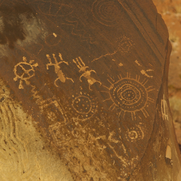 Immersive Experience


No comments:
Post a Comment