Right now I am working with a child who used to live in Tahoe and she wanted to do her LH&G block on Lake Tahoe. (Live Education suggests renaming this Local History & Industry to keep it separate from U.S. History, which Waldorf does later. The industries of the region drive a lot of local life.)
So I am going to keep some notes here as we go through this topic. She wants to begin with some of the local animals, which also works for Grade 4 because it's the Zoology year.
Note: Which Way To The Wild West? Everything Your Schoolbooks Didn't Tell You About Westward Expansion by Steve Sheinkin was our main text for this block.

Geography - Introduction
- find Nevada on a world globe
find Nevada on a U.S. political map
find The Great Basin on a U.S. topograpical map
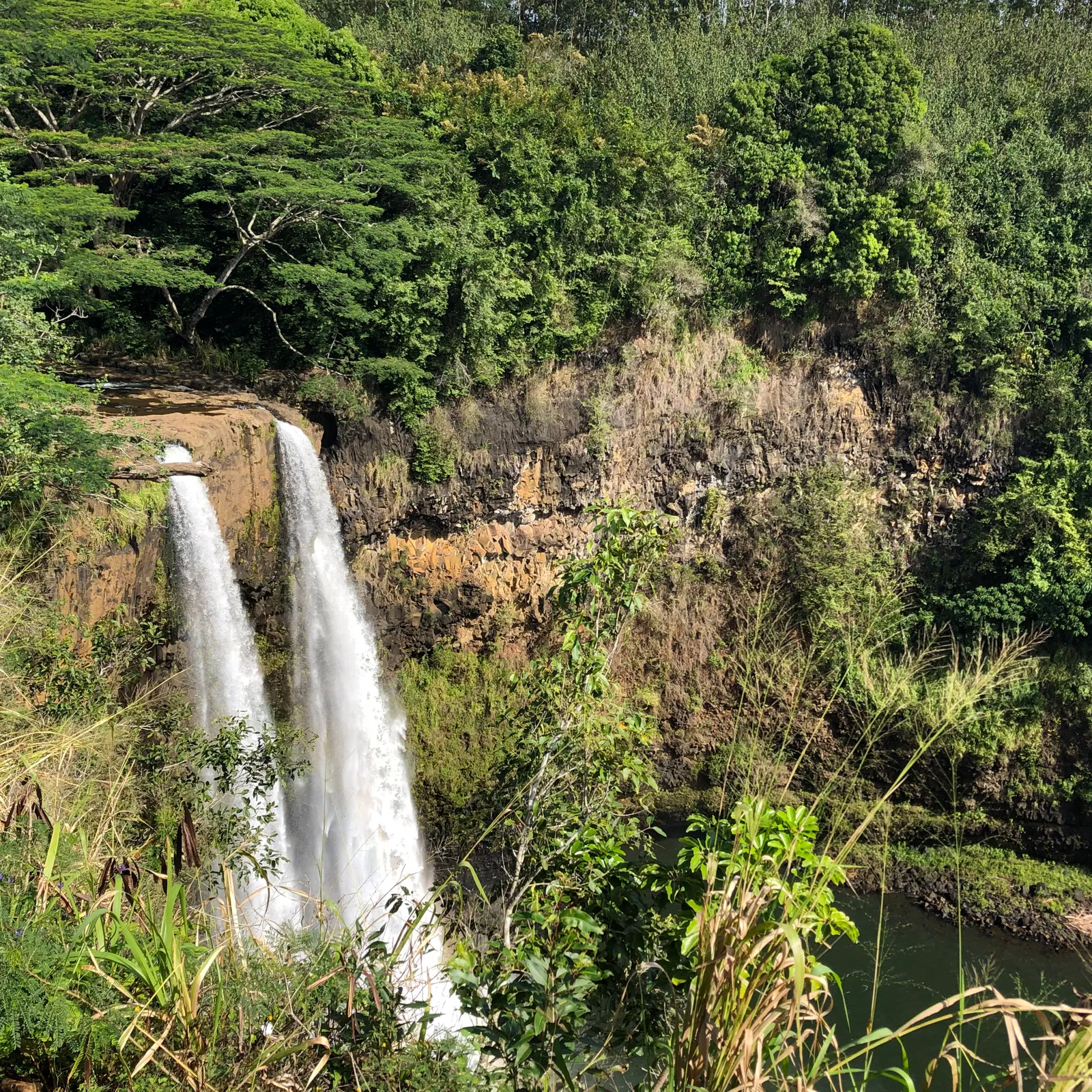
find Lake Takoe on a Nevada map
Native People - Washoe
-
identify the Native people of the Lake Tahoe area (Washoe)
https://native-land.ca
Birds

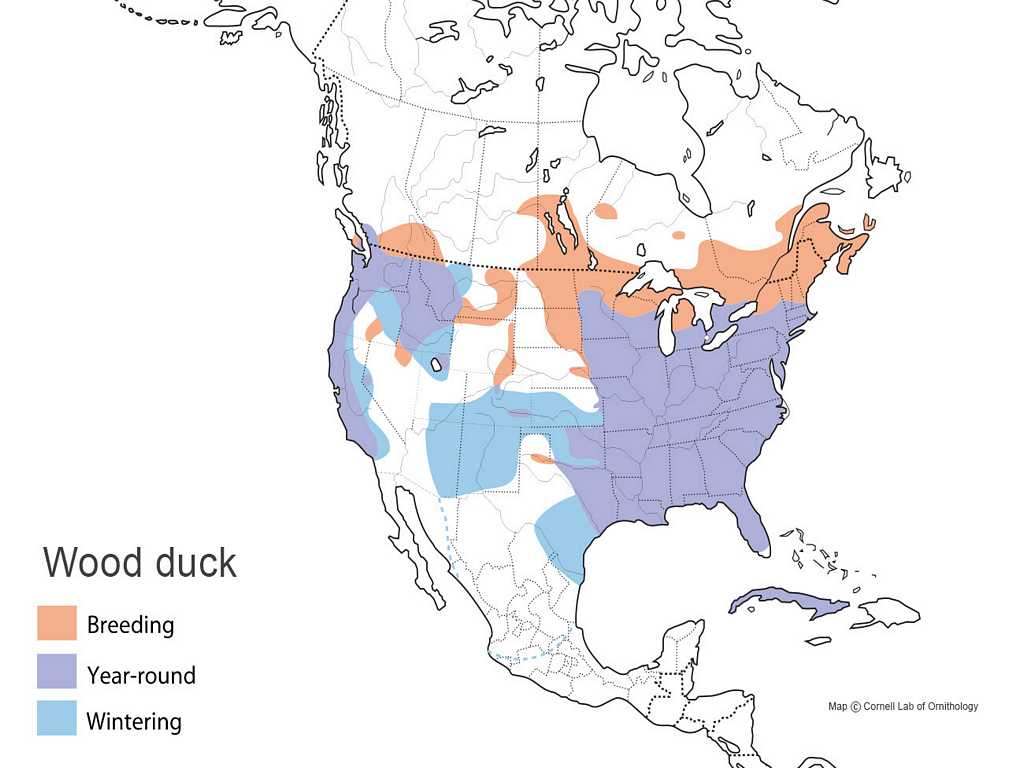
A Nest of Wood Ducks
by Evelyn Shaw
find Lake Tahoe on the Wood Duck Map
look at a beautiful picture of the male wood duck
watch video of ducklings (less than 24 hours old) leaping from a tree
Mammals
-
Mammals of the Lake Tahoe Basin
visitlaketahoe.com
Mammals of the Lake Tahoe Basin
usda.gov
Mule Deer
Horns and Antlers
by Wilfrid Swancourt Bronson
chapter 1, "Horns and Antlers" (pp.3-26)
chapter 3, "Mule Deer" (pp.74-86)

Black Bear
Black Bear Cub
by Alan Lind

Coyote
Coyotes
by Victoria Blakemore

Raccoon
Raccoons
by Victoria Blakemore

Zombie Makers: True Stories of Nature's Undead
by Rebecca Johnson
chapter 4, "Going Viral" (pp.30-33)

Squirrel
Squirrels
by Victoria Blakemore

The Chisel-Tooth Tribe
by Wilfrid Swancourt Bronson
chapter 1, "The Chisel-Tooth Tribe in General" (pp.3-21)

Night Gliders
by Joanne Ryder

Porcupine
Miss Hickory
by Carolyn Sherwin Bailey
reference to "Quill Pig" (p.79)

Porcupines
by Victoria Blakemore

Animal Poems
by Valerie Worth
"Porcupine"

Dark Emperor & Other Poems of the Night
by Joyce Sidman
"I Am a Baby Porcupette" (pp.18-19)

History - Introduction

Dandelions
by Eve Bunting
Coyotes
by Wilfrid Swancourt Bronson

American Frontier (Wikipedia)
this has particularly useful maps:
1789: The new nation
1845–1846: Before Mexican–American War
1884–1889: Post–Civil War expansion
A Brief History of Tahoe and Its People
visitlaketahoe.com
read through "A new era was born, and many Californians were enjoying the flourishing economy, including Lake Tahoe."
Levi Strauss Gets A Bright Idea: A Fairly Fabricated Story of a Pair of Pants
by Tony Johnston

Don't Touch My Hat!
by James Rumford

Which Way to the Wild West?
chapter 1: How the West Moved West

Bad River Boys: A Meeting of the Lakota Sioux with Lewis and Clark
by Virginia Driving Hawk Sneve
(instead of "Step 5: Meet Your Neighbors," pp.9-11)

chapter 2: Did Someone Say "Manifest Destiny?"
look at map of the U.S. states and territories
Dec 29, 1845 to Jun 18, 1846
play The Oregon Trail game online for free
this link is to the Mac version; click Fullscreen
(play game after reading "You Call This a Party?," pp.47-49)
look at map of the Oregon Trail
look at map of the California Trail
do Manifest Destiny SHEG lesson
chapter 3: War, Land, Gold, Trouble
- look at California state flag
look at map of the original size of Mexico (Mexico in 1824)
look at map of the land we got from Mexico (white portion)
this map is nice because the modern state lines are included
do Gold Rush SHEG lesson
a wondering: was gold was ever found at Tahoe?
The Last Prospectors
tahoequarterly.com
chapter 4: Welcome to the Wild West
-
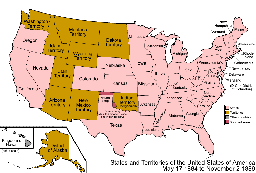
look at 1856 Map of the United States and compare with the state borders of today
look at 1856 Map of the Western States and compare with the Western states of today
revisit map of the Oregon Trail and find the gold fields
revisit map of the California Trail and find Tahoe
read Tjatjakaymatchan (Coyote) legend
available online for free at the International Children's Digital Library
(read after reading "Advancing Civilization?," pp.84-85)
do United States of America Order of Statehood activity (revisit 1856 map and 1889 map partway through)
- this blank US map with states numbered in order of statehood is available on TpT for $2.50
In fact, she designed it based on my suggestion! When I was teaching Westward Expansion, I would always have my students sit down one day and color a blank US state map in the order that the states joined the Union. We just use one color of pencil for this. It is fun to watch the color move slowly across the page. It is really fun to see West Virginia stay white for so long (WV broke off from VA over the issue of slavery... WV became a free state while VA stayed a slave state).
When I gave feedback to the seller for her very nice blank US state map, and told her how I was using it, she created a new map which has the states numbered in order of statehood! This is really handy if you are working with a child who doesn't feel confident recognizing the states if you just called out the names in order.
The next time I do this, I think what I would like to do is to have two colors. Color the original 13 in one color (this was the starting size of our country) and then color the remaining 37 in a second color.
It may also be interesting to fill out the map key page with the 2 letter postal abbreviation beside the year the state joined the Union. That way children can see the passage of time in a different way. List of States by Statehood Date (PDF)
note: when we got to "Indian Territory" on the 1889 map, she asked to see a map of the current Tribal
Lands in the US (there are 574):
Indian Reservations in the Continental United States
we revisited the Topography of the United States as well (the Navajo people, the only indigenous people allowed to return to their homeland, were living on desert land that wasn't good for farming)
chapter 5: Out of the Way of the Big Engine
-
NOTE: cover Pony Express information before beginning the chapter
National Pony Express Association
1860–1861 History
Stations
The Pony Express Rides Again
visitlaketahoe.com
revisit painting from the Manifest Destiny lesson and point out the telegraph wire in her hand
Samuel Morse, That's Who!
by Tracy Nelson Maurer

Morse Code (PDF)
The Long Way Westward
by Joan Sandin
(read after "How to Steal Millions: Part III," pp.107-108)

The Bozeman Trail: A Rush to Montana's Gold
(watch after "War Spreads North" and "The Shocking Fetterman Fight," pp.114-117)
chapter 6: Race You to Utah

Locomotive
by Brian Floca
do Evaluating Historical Sources on Juana Briones SHEG lesson
(after "Blasting Through the Mountains," pp.127-129)
chapter 7: Cowboys vs. Farmers
-
I loved her "Cowboys" 2-page spread in the MLB. Her illustration was of a campfire with musical notes all around it, and we listened to Git Along Little Dogies (AMERICAN FOLK SONGBOOK by
Suzy Bogguss) while she was drawing. She loved it so much she added all the lyrics to her MLB (two more 2-page spreads)!
Cowboys and Cowgirls: Yippee-yay!
by Gail Gibbons

read desired chapters after "It's Not Getting Easier," pp.164-165:
by Laura Ingalls Wilder
chapter 25 "The Glittering Cloud"
chapter 26 "Grasshopper Eggs"
chapter 32 "Grasshoppers Walking"

chapter 37 "The Long Blizzard"
chapter 38 "The Day of Games"
chapter 39 "The Third Day"
chapter 40 "The Fourth Day"
The Long Winter
by Laura Ingalls Wilder
chapter 21 "The Hard Winter"
chapter 23 "The Wheat in the Wall"
chapter 24 "Not Really Hungry"

Georgia O'Keeffe was our artist study this week, and it seemed to fit in really well!
My Name is Georgia
by Jeanette Winter
Georgia O'Keeffee (1887 - 1986)

chapter 8: The Road to Little Bighorn &
chapter 9: The End of the Wild West

Buffalo Dance: A Blackfoot Legend
by Nancy Van Laan
(read after "Goodbye, Buffalo," pp.172-173)
A Boy Called Slow: The True Story of Sitting Bull
by Joseph Bruchac
(read after "Another Miserable Job," pp.177-179)

When getting A Boy Called Slow from the library, I discovered a few things. One was that the Dewey Decimal Number for the Wild West is 978. Another was that S.D. Nelson had created several books about famous Native American chiefs of this time period: Red Cloud, Sitting Bull, and Black Elk. We read all three of them.

Red Cloud: A Lakota Story of War and Surrender
by S.D. Nelson
Sitting Bull: Lakota Warrior and Defender of His People
by S.D. Nelson

Black Elk's Vision: A Lakota Story
by S.D. Nelson

Fry Bread, When We Were Alone, and Stolen Words would also fit well with this part of the story.

Fry Bread: A Native American Family Story
by Kevin Noble Maillard
When We Were Alone
by David Robertson

Stolen Words
by Melanie Florence

Special Note: The Fort Laramie Treaty of 1851 was brought back up during the 2016 fight over the Dakota Access Pipeline (DAPL).
Treaties Still Matter: The Dakota Access Pipeline
Dakota Access Pipeline page at Wikipedia

We Are Water Protectors
by Carole Lindstrom
After the desired extra resources, resume Which Way to the Wild West? with page 179 "Custer's Not Worried" and read the remainder of the book through the end of
chapter 9: The End of the Wild West.
You will have to decide how much actual history is suitable for this block, depending on the age of your child. For example, if you are homeschooling in a mixed-age environment, your older child might do some of the lessons from Stanford History Education Group and your younger child would not.
Here is the full List of Reading Like a Historian Lessons.
Some lessons which would tie in well with Which Way to the Wild West?:
- Louisiana Purchase
Lewis and Clark SAC
Texas Revolution
Manifest Destiny OUT
Gold Rush and San Francisco
Irish in 19th-Century America
Evaluating Sources on Juana Briones
Reconstruction SAC
Thomas Nast's Political Cartoons
Great Plains Homesteaders
Battle of Little Bighorn
This post contains affiliate links to materials I truly use for homeschooling. Qualifying purchases provide me with revenue. Thank you for your support!

 Immersive Experience
 Immersive Experience
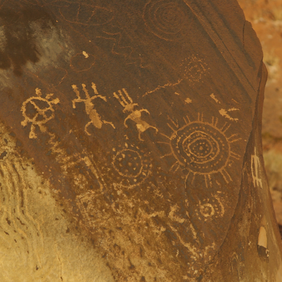 Immersive Experience


.png)
No comments:
Post a Comment